The 10 Participating St'at'imc Communities Served by the STPS
Lil'wat

The community of Lil'wat is located in Mount Currie, an area known as southern St'at'imc traditional territory.
"The Lil’wat have never given or sold any of our land to any government or nation. Although settlers and colonial governments marginalized us from the land, we never relinquished our right (in law or in our hearts) to our home. In our endeavors to restore and preserve our rights we have earned a reputation for political resistance. We are willing to stand up for what we believe in — it is essential for the survival of the Lil’wat Nation. In 1911, the Lil’wat people joined First Nation communities throughout the region in signing the Lillooet Declaration at Spence’s Bridge. The declaration outlined the demands for the reinstatement of our right to our traditional lands and was a primary example of First Nations solidarity and political resistence. The issues raised remain unresolved 95 years later."
N'Quatqua

N'Quatqua community can be found in D'arcy which is located in southern St'at'imc.
"N’Quatqua was established as a Reserve under the Indian Act in September of 1858. N'Quatqua Band Office has been providing services to our Membership since our founding in 1987. It is our mission to promote and encourage families to create and maintain a healthy community. We support the development of self-governance while respecting our relationship with the land, culture and language. We believe the best way to achieve this goal is to honour and respect our lands and resources through a holistic approach. We will be committed to a strong, loving, healthy and sustainable community that will have a consistent approach to education, culture and language. That we will have a self governance system that will allow us to grow and meet our needs."
Xa'xtsa

The Xa'xtsa communities are near Douglas in southern St'at'imc.
"Xa’xtsa is made up of two communities: Port Douglas, which is situated at the northern end of Little Harrison Lake, and Tipella which is on the west side of the Lillooet River. Xa’xtsa is the southernmost of the In-SHUCK-ch communities, and also of the entire St’at’imc linguistic group. The name 'Port Douglas' originates from the colonial period, when the town, one of the earliest to be established in mainland British Columbia, was erected adjacent to the present Xa’xtsa community in 1858. It was the starting point on the Harrison-Lillooet wagon road, also known in historic times as the Douglas Portage."
Skatin

The community of Skatin can be found at Skookumchuck, a part of southern St'at'imc.
"Skatin (or Skookumchuck) is located on the east side of the Lillooet River, on the 19-Mile Post of the old Harrison-Lillooet wagon road (about 35 kilometres from the head of Harrison Lake). Before the arrival of European settlers, this community was considered to be the largest on the lower Lillooet River, comparable in size to the pre-contact village of present-day Mount Currie (or Lilwat'ul)."
Samahquam

Samahquam is located at Baptise Smith in southern St'at'imc.
"There was a valley-wide outmigration which began in earnest around 1950, because of the isolation and absence of services, opportunity and jobs. As a result, the Samahquam Ucwalmicw had no permanent resident population on their Indian reserves of Baptiste Smith 1 and 1a, Samahquam IR1 and Sachteen IRs 2 and 2a before 1990.
They had to overcome INAC’s policy of not funding capital works, infrastructure, and even community development planning for Indian reserves that had no resident populations. With no resident populations, there was no access to INAC funding support. This began turning around in the mid-1980s, when Samahquam the leadership secured Canada Employment support and used band funds to begin planning."
T'it'q'et

T'it'q'et community in Lillooet is located in northern St'at'imc.
"We have occupied the traditional lands within the St’at’imc Territory for thousands and thousand of years. Our ancestors have lived and survived off the St’at’imc land. We live off the land along with surviving the modern world. Like our ancestors before us, every summer is when we’re at the fish rocks getting ready to can, dry or smoke our fish for the winter. We pick our medicines and berries from our beautiful mountains. We hunt and give thanks to the animals. We are the Peg’pig’lha Clan of the St’at’imc Territory."
Sekw'el'was

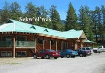
Sekw'el'was at Cayoose Creek is a northern St'at'imc community.
"Sekw'el'was/Cayoose Creek is located near town of Lillooet. Made up of three reserves; 720.1 hectares. Main community is on Cayoose Creek I.R. No. 1and services three reserves. The reserve was established August 29, 1881. Its water is supplied by piped water system, community well and reservoir; sewage is disposed in septic tanks. Services, such as health care and fire protection, etc., are provided in Lillooet.
Sek'wel'wás (Literally: broken in half, refers to big rock)"
Tsal'alh

Tsal'alh near Seton Lake is a northern St'at'imc community.
"We, the Tsal'alhmec, original caretakers of our land, respect the wisdom and knowledge from our ancestors and take pride in our healthy, self sustaining community.
The Nature of Our Lands The berries in our native land are one of our main resources. These are some of the berries our land provides us with: Currants, Soap Berries, Huckle Berries, and Saskatoon Berries.
The Nature of Our Waters The water provides us with various types of fish. In Seton's two beautiful lakes you will find Rainbow Trout, Mountain White Fish, Dolly Vardon, Pink Salmon, Chinook, Coho, and Steelhead.
The Nature of Our Wildlife St'át'imc people have always shared the land with other living creatures. In this area we often see bears, deer,eagles, hawks, owls, cranes, wolves,bob cats, and cougars."
Ts'kw'aylaxw

Ts'kw'aylaxw can be found in Pavilion, a northern St'at'imc community.
"Ts'kw'aylaxw First Nation also known as Pavilion Indian Band is located in the south central interior of BC, approximately 40 km northwest of Lillooet and 70 km west of Cache Creek. The Band has eight reserves but reside on only four of the reserves.
28% of the members live on-reserve and 72% live off reserve."
Xaxli'p

Xaxli'p, near Lillooet, is a northern St'at'imc community.
"Xaxli’p “Mission Statement” is to be proud, independent, self-sufficient Xaxli'pemc and continue to pursue a land settlement with the Canadian Government; Work with the best interest of Xaxl'ipmec with support, trust and respect of one another. For all to be opened minded.
Xaxli’p formally known as Fountain Band, is a First Nations government located about 15 km from the Village of Lillooet on Highway 99 north, in the Central Interior-Fraser Canyon region of the Canadian province of British Columbia. Xaxli’p is a member of the Lillooet Tribal Council, which is the largest grouping of band governments of the St'at'imc people (a.k.a. the Lillooet people). Other St'at'imc governments include the smaller In-SHUCK-ch Nation on the lower Lillooet River to the southwest, and the independent N'quatqua First Nation at the farther end of Anderson Lake from Seton Portage, which is the location of three of the reserve communities of the Seton Lake First Nation, aka the Seton Lake Indian Band."
"Our force may be small, but we serve each day with honour and respect."
- Stl'atl'imx Tribal Police Service.